We are all familiar with buying a product that requires assembly, typically furniture or some kind of toy-like contraption if you have kids. The expectation is there will be a list of parts (all identified), a list tools necessary for the assembly, and instructions taking you step-by-step through the process. Sometimes, there are pictures and drawings showing the assembly steps. It just makes sense.
Imagine the level of frustration and anxiety you would feel if, when you open the box, out falls a bag full of screws, bolts, washers, nuts, and other unidentifiable parts and nothing else. That is how I felt the first time I used AERMET back in the early 2000’s.
Guiding You Through the AERMET Guidance
To even get started with AERMET, you have to have the appropriate data files in the appropriate format ready for AERMET to do its thing, thing, and thing. The user’s guide mentions data available on CD-ROM or magnetic tape or abbreviated datasets for download, but why would you do that to yourself?
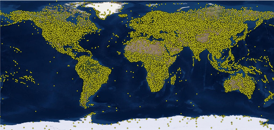
For use with AERMET, the only data source necessary is from the National Oceanic and Atmospheric Administration (NOAA) at ftp://ftp.ncdc.noaa.gov/pub/data/noaa. NOAA has available, for free, data from 1901 to the present. Also, the spatial extent of the data is very robust. See the graphic down below. It is recommended you use an FTP client rather than a web browser to access and copy the data you need. A popular FTP client that is easy to use can be found at https://filezilla-project.org/.

It’s Easy To Do Once You Know How
Once you are at the NOAA ftp site, locate the year(s) of data needed and then the file(s) needed. Each year has a separate directory, but the files have a specific naming convention to identify which station they came from. The file naming convention is, <USAF ID>-<WBAN ID>-<4-digit year>.gz, where:
- USAF ID is the United States Air Force ID code; and
- WBAN ID is the Weather Bureau Army Navy ID code.
To look up what identifiers are for a weather station, there are two data sources you can go to:
Both websites have lots of useful information beyond just the station identifiers. The Weather Graphics site has a free and for-cost data sets. The site from the University of Illinois does require you set up a user account, but it is free.
Give Me an AERMINUTE To Explain
If you are performing dispersion modeling for an air quality permit, you are most likely required to use AERMINUTE in concert with AERMET. The surface observations described previously are typically a two-minute average (for wind speed, wind direction, temperature, etc.) taken ten minutes before the top of an hour, e.g. 10:50, 11:50, etc. AERMINUTE uses one-minute and/or five-minute readings taken by Automated Surface Observing Systems (ASOS) to assist AERMET deriving an actual one-hour average value for the meteorological parameters used by AERMOD. Also, since ASOS is less expensive than human observers, many more stations have ASOS than those previously reporting hourly observations to NOAA.
ASOS data can be found at:
The data gathered is presented in two separate file series, 6405 and 6406, for the one-minute data. For AERMET you only need the 6405 series.
The naming convention for the files is 64050<call ltrs>YYYYMM.dat, where the call_ltrs are the four-character call letters for the weather station. You can find that identifier is the same locations as the USAF ID and WBAN ID. Also, the files have data for each calendar month, so a complete year will have 12 files for you to download. As mentioned above, it would be easier to use an FTP client than a web browser to obtain these files.
Just When You Thought You Were Done, There’s More
As ASOS were installed at weather stations, the instrumentation changed, such as for the wind speed. Prior to ASOS, cupped weather vanes measured wind speed. In areas where snow and ice occur, these instruments could literally freeze up. The newer instrumentation does not do that. The dates when a weather station changed instruments can be found at http://www.weather.gov/ops2/Surface/documents/IFW_stat.pdf. The date of the instrumentation change is an input item for AERMINUTE.
A List Tools To Use
Once you know where to get the raw meteorological data needed for your project, there are a few tools you can use to easily download the files. There are three that come to mind:
- Your web browser;
- An ftp client (e.g. FileZIlla and others); or
- The NaviKnow GeoDataBase (GDB).
You are most likely familiar with your web browser or ftp clients, but if you haven’t seen the NaviKnow GDB in action, take a look at the following short video. When was the last time (or even the first time) you performed an analysis to find the nearest weather station to your project site, located the 1-hour observations, located the 1-minute observations, and downloaded all needed files in less than 5 minutes? If you viewed the video, you just saw it done.
Summarizing
By using the links to information provided, the time spent locating and downloading hourly, one-minute, and five-minute surface observations for use with AERMET and AERMINUTE should be reduced from hours to just a few minutes.
If you found this article informative, there is more helpful and actionable information for you. Go to http://learn.naviknow.com to see a list or past webinar mini-courses. Every Wednesday (Webinar Wednesday), NaviKnow is offering FREE webinar mini-courses on topics related to air quality dispersion modeling and air quality permitting. If you want to be on our email list, drop me a line at [email protected].
One of the goals of NaviKnow is to create an air quality professional community to share ideas and helpful hints like those covered in this article. So if you found this article helpful, please share with a colleague.
Resources
