
I typically start my articles with a personal story that somehow relates to the topic at hand. The story is meant to draw you in so that an otherwise really dry subject seems a little bit interesting and relatable. For this article, I have decided not to do that because the issues involved are too important even if the subject matter is as dry as the western side of the Andes in Chile.
On February 21st, 2019, the EPA announced proposed updates to AERSURFACE. There are five main changes being proposed:
• Ability to use more recent national landcover datasets (NLCDs);
• Executing AERSURFACE through an input file-based interface similar to most of the other programs in the AERMOD model system;
• New values for roughness length in lookup tables;
• Supplementing NLCD data with impervious and tree canopy data; and
• New, but optional, roughness length calculation algorithm.
In the announcement, EPA is explicitly soliciting feedback on:
• Changes to the roughness length lookup tables;
• Implementation of percent impervious and tree canopy data to supplement NLCD; and
• Implementation of the optional roughness length calculation algorithm (Z0eff).
EPA would like your comments by April 22, 2019. Email all comment to Clint Tillerson at [email protected].
We, at NaviKnow, encourage you to thoroughly review the materials EPA has provided and send EPA all of your comments and suggestions. The more feedback EPA gets, the better the product (AERSURFACE) we get to use.
NaviKnow’s Unofficial Comments
I have reviewed the draft AERSURFACE User’s Guide describing the proposed changes. I haven’t played around with the program, yet, but I plan to soon. All of my comments for now, are based purely on my review of the User’s Guide. When I test out the new program, I will make any adjustments to my comments as necessary.
NaviKnow’s comments fit into two main buckets:
• Welcomed improvements and
• Extreme concerns.
There is really nothing in between.
AERSURFACE Improvements
For years I have slammed AERSURFACE as being woefully out of date, by using landcover data from 1992. Out of professional necessity, I started using the most recent landcover data available (the 2006 NLCD, at the time) with the same algorithms AERSURFACE uses, to develop the surface characteristics for input to AERMET. Besides not wanting to come across as lazy or incompetent, the project I was involved in was very contentious, emotionally charged, and high profile, so all the work had to be done beyond reproach.
The project dealt with lead (Pb) emissions in an area that was very rural farm land in 1992 with a population of about 6,000 to a bustling urbanized urban center by 2010 with a population of close to 200,000 and several sports stadiums, shopping malls, and tollways and freeways. I could have just blindly followed the current modeling guidance, but I had my professional reputation and the reputation of the agency to uphold. Also, I did not want to get yelled at by thousands of residents of the area.
The proposed change to AERSURFACE to have the ability to use more recent NLCDs as input is a very welcomed improvement and long overdue. We give EPA a big thumbs up on this change.
Though it did involve more time and effort to manually calculate surface characteristics using GIS software and a spreadsheet, I much preferred that method of performing the calculations than using the interactive DOS interface of AERSURFACE. Having an input file-based interface is another improvement. It allows for easier automation. We give EPA another thumbs up for this improvement.
Concerns about Proposed AERSURFACE
There are a few items that we have concerns about. From our point of view, EPA could have just stopped with the two improvements mentioned above, and everyone would have been happy about it and EPA would receive a lot of praise. Well, that’s not what happened.
The Seasons
AERSURFACE requires that the months of the year be assigned to a season. From the AERSURFACE User’s Guide it states:
“the user is given the option of assigning the individual months to a seasonal category that is appropriate for the climate and conditions at the specific location. This option will allow a more locally appropriate estimate that is more reflective of the area.”
This sound really good and the user should try to represent the modeled world as closely as practicable to the real physical world. However, the very next sentence in the user’s guide says it is okay to go ahead and just use the default assignment of months to seasons based on the calendar seasons. The way we are interpreting this guidance is, be as accurate as you can but if it is too hard just use the default as it really doesn’t matter.
EPA has really not offered any guidance on a procedure for making a determination of which month should be assigned to which season. NaviKnow has made a proposal for a methodology, but we have had only two comments from the modeling community. We encourage you to review our proposal and comment. It would be our goall to provide EPA with a repeatable and objective approach.
There is another tiny change when it comes to the seasons, but it is the kind of tiny change that causes me to question why? Below are the seasons as they are listed in the current AERSURFACE User’s Guide:
1 - Midsummer with lush vegetation
2  - Autumn with unharvested cropland
3 - Late autumn after frost and harvest, or winter with no snow
4  - Winter with continuous snow on ground
5 - Transitional spring with partial green coverage or short annuals
In the proposed changes, the seasons are listed as below:
4 - Midsummer with lush vegetation
5  - Autumn with unharvested cropland
1 - Late autumn after frost and harvest, or winter with no snow
2  - Winter with continuous snow on ground
3 - Transitional spring with partial green coverage or short annuals
It really doesn’t make a difference, but still why the change? As a result, all the lookup tables had to be changed. It made it very confusing when trying to compare old values to new values. Seems like a lot of extra work with no apparent benefit.
Urban Roughness Length Values
Though the reordering of the seasons was a bit of an annoyance, the proposed changes to the urban roughness lengths in the lookup table is a matter of significant concern. At NaviKnow, we found the values in the current version of AERSURFACE questionable, especially for the most urbanized areas. It did not make sense to us that the most developed areas with the tallest structures, like large buildings, distillation columns, manufacturing buildings, and fields of large storage tanks, would have a LOWER roughness length than a residential area.
The current values used internally by AERSURFACE are below. The urban land cover categories are highlighted.
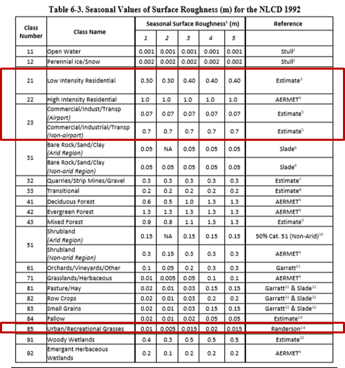
It just doesn’t make any sense that residential areas would have a larger surface roughness length than commercial areas (malls and office buildings) and industrial areas (manufacturing plant or refinery). A review of the literature and the WMO training guide show that for urban areas, the roughness length is larger as the structures get taller and more dense.
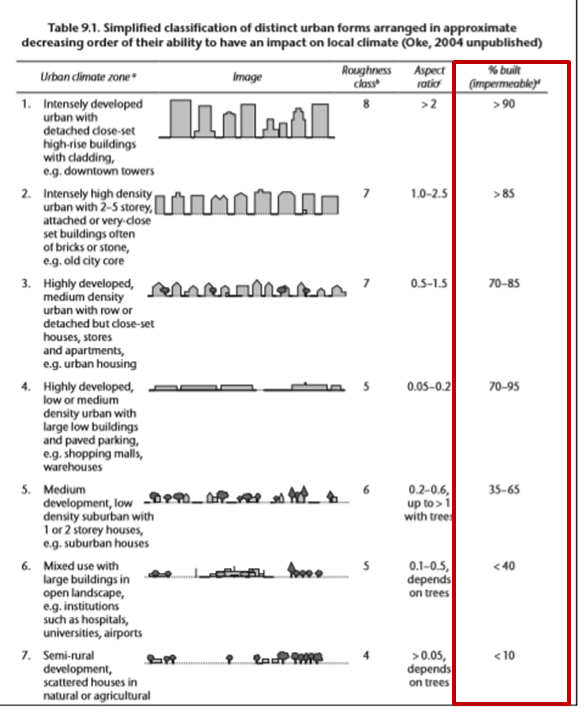
The WMO guide, as does the NLCDs, uses the metric percent of the ground being impermeable, kind of the inverse of percent covered with vegetation. Notice the roughness class used in the WMO guide, where the larger and more dense structures are, the higher the class, implying a larger roughness length.
Also in the WMO guide, is a listing of the roughness length values by roughness class and description of the land cover.
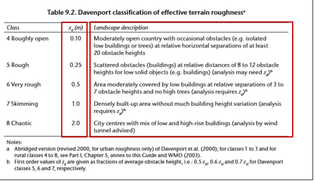
Given all this information, NaviKnow’s proposal of using 1.5 meters for the most urban land cover category would not be out of line. However, all of this information is the reason for our concern regarding the proposed roughness length values in AERSUFACE.
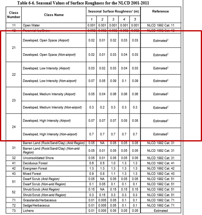
Below are the proposed values for use with AERSURFACE. The urban values are highlighted. Notice that they are lower, significantly lower, than the current values and those used in the WMO guide.
After reading through the proposed draft AERSURFACE User’s guide, there are two sources for what we see as flawed data:
• AERSURFACE being applied at the location of the NWS station meteorological data gathering tower.
• An obscure reference (I’m still looking for it) that makes a blanket statement that airports have a roughness length of 0.03 m
In a past article, Where to apply AERSURFACE?, we describe the history of AERMOD, AERMET, and AERSURFACE and what decisions were made behind the scenes and why. In a nutshell, EPA dropped any requirement that, if only NWS data are used, AERSURFACE be applied at the location where the meteorological data gathered. Even in the AERSCREEN User’s Guide it states:
“When determining surface characteristics, the user should consider the location of the source”
The issue of where to conduct your land cover analysis was litigated and agreed to a long time ago, but it seems, every so often, an artifact of the original proposal shows up.
In the analysis in the appendices of the proposed AERSURFACE User’s guide, the rationale for having such low roughness length values is that the urban categories use percent of land cover being impervious as a metric rather than percent covered with vegetation. If you ONLY look at airports, runways are very impervious but are also rather free of obstructions. So, ONLY at airports, the roughness length would be overstated because there is a lot of open space free of obstructions to the wind. Taken by itself, the rationale seems reasonable.
The impression I got, and I could be mistaken, is that trees seem to be the most significant obstruction that influences the roughness length value. From the lookup table of values, forests have the highest roughness length values. However, from the WMO guide and the body of literature, forests are listed as having a roughness length of around 1, but city centers and highly developed and urbanized areas having roughness length values larger, e.g. ≥ 2.
Another area of concern is the “urban profile” that is comprised of:
• High Intensity Residential (22)
• Bare Rock/Sand/Clay (31)
• Mixed Forest (43)
• Urban/Recreational Grasses (85)
The issue I see with this “urban profile” is that, first, the land use categories are from the 1992 NLCD and secondly, it only considers urban grasslands (parks and open areas) and residential areas from the urban categories. Since the 1992 NLCD is no longer a valid dataset and the more recent datasets use slightly different criteria, the use of 1992 NLDC categories is confusing. Also, developed and urbanized areas are made up of more than residential areas, such as malls, high-rise office and residential buildings, and industrial complexes.
To demonstrate my concern, let me provide an example. The image below is of where I used to live. A suburban area with single resident homes. Each lot had a few trees and some of the main streets through the subdivision were tree-lined. Most of the trees were relatively mature ranging from 25-45 feet tall.
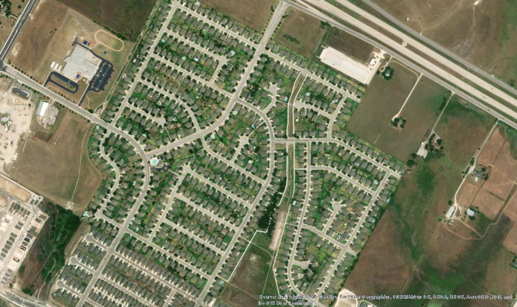
The same area (same scale), through the eyes of the 2011 NLCD, looks like this:
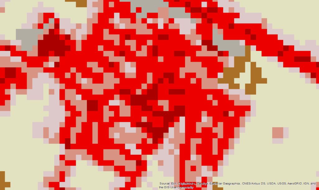
The houses, driveways, and streets are classified as 22’s and 23’s, with the more wooded areas and taller trees showing up as 24’s.
The image below (using the same scale) is where I live now. A very urban residential area with townhouses, brownstones, and high-rise apartments. There are also shopping centers and some low-rise office buildings. Also, very few trees.
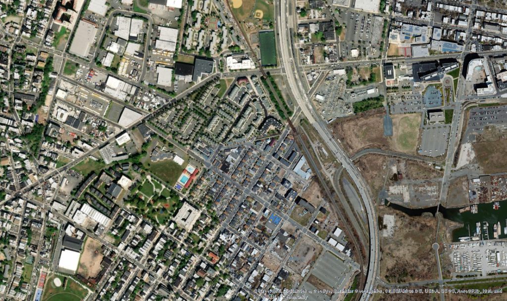
The representation (same scale) of this area with the 2011 NLCD looks like:
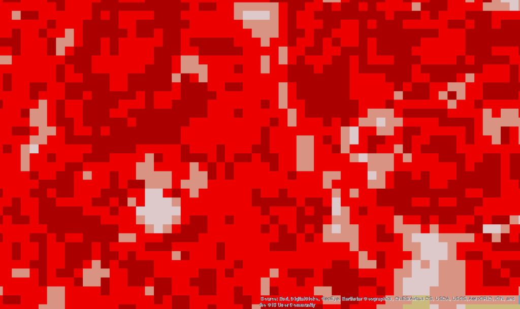
The area is mostly classified as 23’s, with 24’s where taller buildings are.
An added inconsistency is, if the URBANSRC option is used, a roughness length of 1 meter would be applied to selected sources. It seems odd and inconsistent that a value as high as 1 meter can be applied to individual sources but not the average value of the entire area if it was actually very urbanized.
Visually, there is no comparison. Where I live now definitely has the larger roughness length. The concern I have is, with the different roughness length values and supplementing the land cover data with canopy data, my old neighborhood would have the larger roughness length. I haven’t tested it, but if so, or even if it was close, that is NOT correct. The bigger concern is having to defend (in court, for example) the choices I would make by using values and a method that make more physical sense.
In Summary
Having AERSURFACE capable of processing more recent
The comments made are our opinions and yours may be very different. In any event, we encourage you to comment to EPA by April 22nd and let them know what you think.
If you found this article informative, there is more helpful and actionable information for you. Go to http://learn.naviknow.com to see a list of past webinar mini-courses. Every Wednesday (Webinar Wednesday), NaviKnow is offering FREE webinar mini-courses on topics related to air quality dispersion modeling and air quality permitting. We also have articles air quality issues at http://naviknow.com/news. If you want to be on our email list, drop me a line at [email protected].
One of the goals of NaviKnow is to create an air quality professional community to share ideas and helpful hints like those covered in this article. So if you found this article helpful, please share with a colleague.